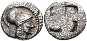
Aenea (city)

Aenea (/əˈniːə/; Ancient Greek: Αἴνεια, Aineia) was an ancient Greek city in northwesternmost Chalcidice, said to have been founded by Aeneas, and was situated, according to Livy, opposite Pydna, and 15 miles from Thessalonica. It appears to have stood on the promontory of Megalo Embolo, which forms the northwest corner of the peninsula of Chalcidice, and which, being about 10 geographical miles in direct distance from Thessalonica, may be identified with the promontory Aeneium of Pseudo-Scymnus. Aeneia must therefore have been further north than Pydna. It was colonised by the Corinthians.[1] It is mentioned by Herodotus, and continued to be a place of importance down to the time of the Roman wars in Greece, although we are told that a great part of its population was removed to Thessalonica, when the latter city was founded by Cassander.[2] The city minted coins in antiquity, some of which survive today. The site of Aenea is located near modern Michaniona.[3][4]
See also
References
- ↑ Scymnus Ch. 627.
- ↑ Herodotus vii. 123; Strabo p. 330; Dionys. i. 49; Lycophron 1236 and Schol.; Virgil Aeneid iii. 16; Stephanus of Byzantium s. v.; Livy xl. 4, xliv. 10, 32; William Martin Leake, Northern Greece, vol. iii. p. 451.)
- ↑ Richard Talbert, ed. (2000). Barrington Atlas of the Greek and Roman World. Princeton University Press. p. 50, and directory notes accompanying. ISBN 978-0-691-03169-9.
- ↑ Lund University. Digital Atlas of the Roman Empire.
File:PD-icon.svg This article incorporates text from a publication now in the public domain: Smith, William, ed. (1854–1857). "Aeneia". Dictionary of Greek and Roman Geography. London: John Murray. 40°28′38″N 22°49′44″E / 40.47717°N 22.82899°E