Mongo, Indiana
From The Right Wiki
Jump to navigationJump to search
Mongo, Indiana | |
|---|---|
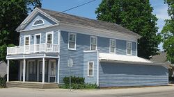
 Mongo's "Olde Store" | |
| Coordinates: 41°41′03″N 85°16′42″W / 41.68417°N 85.27833°W | |
| Country | United States |
| State | Indiana |
| County | LaGrange |
| Township | Springfield |
| Elevation | 906 ft (276 m) |
| Population (2010) | |
• Total | 105 |
| ZIP code | 46771 |
| FIPS code | 18-50094[2] |
| GNIS feature ID | 2830436[1] |
Mongo is an unincorporated community in Springfield Township, LaGrange County, Indiana. The population in 2010 was 105.[3]
History
Mongo was originally called Mongoquinong, and under the latter name was laid out in 1840.[4] Mongoquinong was later shortened to Mongo. Although An Illustrated Historical Atlas of LaGrange County, Indiana (1874) translates the native name as 'Big Squaw Village', it is thought to be a corruption of the Miami-Illinois maankwahkionka, meaning 'in the Loon Land'.[5][6] The John O'Ferrell Store was listed in the National Register of Historic Places in 1975.[7]
Geography
Mongo is the site of "The Olde Store" (aka "John O'Ferrell Store" or the "Mongo Trading Post"), on the National Register of Historic Places.
References
- ↑ 1.0 1.1 U.S. Geological Survey Geographic Names Information System: Mongo, Indiana
- ↑ "U.S. Census website". United States Census Bureau. Retrieved January 31, 2008.
- ↑ "ZIP Code 46771, Mongo IN, U.S. ZIP Codes, Database - Mongo Indiana Map".
- ↑ Counties of LaGrange and Noble, Indiana: Historical and Biographical. F.A. Battey & Company. 1882. p. 203.
- ↑ McCafferty, Michael. Native American Place Names of Indiana. Champaign: U of Illinois P, 16. ISBN 978-0-252-03268-4.
- ↑ "Indiana's quirky place names and how they came to be".
- ↑ "National Register Information System". National Register of Historic Places. National Park Service. July 9, 2010.