Schore, Netherlands
Schore | |
|---|---|
Village | |
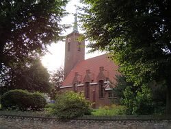
 De kerk van Schore | |
|
Coat of arms of Schore Coat of arms | |
Location in the province of Zeeland in the Netherlands Schore (Netherlands) | |
| Coordinates: 51°27′42″N 3°59′58″E / 51.46167°N 3.99944°E | |
| Country | Netherlands |
| Province | Zeeland |
| Municipality | Kapelle |
| Area | |
• Total | 3.11 km2 (1.20 sq mi) |
| Elevation | −0.1 m (−0.3 ft) |
| Population (2021)[1] | |
• Total | 485 |
| • Density | 160/km2 (400/sq mi) |
| Time zone | UTC+1 (CET) |
| • Summer (DST) | UTC+2 (CEST) |
| Postal code | 4423[1] |
| Dialing code | 0113 |
Schore is a village in the Dutch province of Zeeland. It is located in the municipality of Kapelle, about 8 km southwest of Goes. The village was first mentioned in 1253 as Dodinus de Scoren, and means "land on water".[3] Schore is a circular church village.[4] Schore was founded after 1150 when a dike was built around Zuid-Beveland. The village was flooded and destroyed in 1248. It was later rebuilt as a small agricultural community. Schore was home to 261 people in 1840.[5] The old centre was destroyed in 1940 by war, and redesigned by Jordanus Roodenburgh.[4] The Dutch Reformed church is an aisleless church was a narrow needle spire which was completed in 1942.[4] Schore was a separate municipality until 1941, when it was merged with Kapelle.[6] It is part of the province of Zeeland, with a population of 485 people
References
- ↑ 1.0 1.1 1.2 "Kerncijfers wijken en buurten 2021". Central Bureau of Statistics. Retrieved 20 April 2022.
- ↑ "Postcodetool for 4423AA". Actueel Hoogtebestand Nederland (in Nederlands). Het Waterschapshuis. Retrieved 20 April 2022.
- ↑ "Schore - (geografische naam)". Etymologiebank (in Nederlands). Retrieved 20 April 2022.
- ↑ 4.0 4.1 4.2 Piet van Cruyningen & Ronald Stenvert (2003). Schore (in Nederlands). Zwolle: Waanders. ISBN 90 400 8830 6. Retrieved 20 April 2022.
- ↑ "Schore". Plaatsengids (in Nederlands). Retrieved 20 April 2022.
- ↑ Ad van der Meer and Onno Boonstra, Repertorium van Nederlandse gemeenten, KNAW, 2011.