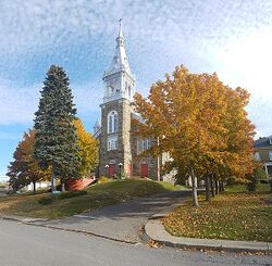
Saint-Octave-de-Métis
Saint-Octave-de-Métis | |
|---|---|
 Church in Saint-Octave-de-Métis | |
| Location within La Mitis RCM Location within La Mitis RCM | |
| Lua error in Module:Location_map at line 389: Malformed coordinates value. | |
| Coordinates: Coordinates: Missing latitude Invalid arguments have been passed to the {{#coordinates:}} function[1] | |
| Country | File:Flag of Canada (Pantone).svg Canada |
| Province | File:Flag of Quebec.svg Quebec |
| Region | Bas-Saint-Laurent |
| RCM | La Mitis |
| Constituted | April 25, 1908 |
| Government | |
| • Mayor | Maxime Richard-Dubé |
| • Federal riding | Haute-Gaspésie—La Mitis—Matane—Matapédia |
| • Prov. riding | Matane-Matapédia |
| Area | |
• Total | 75.20 km2 (29.03 sq mi) |
| • Land | 75.16 km2 (29.02 sq mi) |
| Population | |
• Total | 493 |
| • Density | 6.6/km2 (17/sq mi) |
| • Pop 2016-2021 | Decrease 3.5% |
| • Dwellings | 221 |
| Time zone | UTC−5 (EST) |
| • Summer (DST) | UTC−4 (EDT) |
| Postal code(s) | |
| Area code(s) | 418 and 581 |
| Highways | File:Qc234.svg R-234 |
Saint-Octave-de-Métis is a parish municipality in Quebec, Canada.
History
The first settlers began arriving in this area, called "Métis" around 1840. In 1855, the municipality of Métis was officially founded. In 1859, a sector of Métis splitted and became the new municipality of Mac Nider. One year later, in 1960, Métis changed is name to Saint-Octave the Métis. The municipality lost signification portions of its territory twice before the end of the 18 century. First in 1878 for the creation of Saint-Moïse and again in 1897 for the creation of Petit-Métis. Finally in 1908, Saint-Octave-de-Métis was divied in two distinct municipalities: Saint-Octave-de-Métis and Saint-Octave-de-Métis-Sud.[1] This municipality was therefore officially created in 1908 under the name Saint-Octave-de-Métis-Sud. and was created by the division of Saint-Octave-de-Métis. In 1931, the original municipality of Saint-Octave-de-Métis changed its name to Grand-Métis, therefore, Saint-Octave-de-Métis-Sud took the current name of Saint-Ocatve-de-Métis. In 1952, Saint-Octave-de-Métis lost an important portion of its territory for the creation of Les Boules, which as since been merged with Métis-sur-Mer.
Demographics
In the 2021 Census of Population conducted by Statistics Canada, Saint-Octave-de-Métis had a population of 493 living in 207 of its 221 total private dwellings, a change of -3.5% from its 2016 population of 511. With a land area of 75.16 km2 (29.02 sq mi), it had a population density of 6.6/km2 (17.0/sq mi) in 2021.[4]
Notable people
- Jules-André Brillant, born 1888, baptized and educated in Saint-Octave-de-Métis, French Canadian entrepreneur
- Hormisdas Langlais, born in 1890, was a Canadian politician and a seven-term Member of the Legislative Assembly of Quebec
- Marguerite Ruest-Pitre, born 1908, Canadian murderer also known as "Madame le Corbeau", the last woman criminal executed in Canada (1953)
- Marie-Thérèse Fortin, born 1959, Canadian actress
- Anaïs Favron, born in 1977, is a radio and TV host, actress, and improviser
See also
References
- ↑ Jump up to: 1.0 1.1 "Banque de noms de lieux du Québec: Reference number 57331". toponymie.gouv.qc.ca (in français). Commission de toponymie du Québec.
- ↑ Jump up to: 2.0 2.1 "Répertoire des municipalités: Geographic code 09055". www.mamh.gouv.qc.ca (in français). Ministère des Affaires municipales et de l'Habitation.
- ↑ Jump up to: 3.0 3.1 "Profile table, Census Profile, 2021 Census of Population - Saint-Octave-de-Métis, Paroisse (Municipalité de) (PE) [Census subdivision], Quebec". 9 February 2022.
- ↑ "Population and dwelling counts: Canada, provinces and territories, and census subdivisions (municipalities), Quebec". Statistics Canada. February 9, 2022. Retrieved August 29, 2022.
External links
- File:Commons-logo.svg Media related to Saint-Octave-de-Métis at Wikimedia Commons